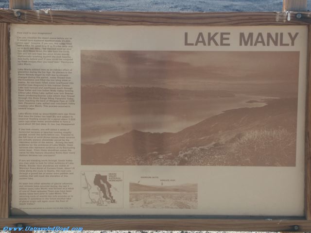
Lake Manly
How vivid is your imagination?
Can you visualize the desert scene before you as
it would have appeared approxmately 20,000
years ago? Imagine, if you can, this valley filled
with a lake, 90 miles long, 6 to 11 miles wide and
up to 600 feet deep. Feel the cool wind on your
face as it blows down the lake from the north.
Can you see and hear the wind driven waves,
rhythmically washing against the dark basaltic
lava butte before you? If your mind has conjured
up these images then you have "seen" Pleistocene
Lake Manly.
Lake Manly existed here as an indirect effect of
glaciation during the Ice Age. As glaciers in the
Sierra Nevada began to melt due to climatic
changes during this period, water flowed from
the mountains and filled the low lying areas or
basins. As one basin filled, water overflowed into
another (see diagram). In this manner Owens
Lake was formed and overflowed south through
Rose Valley and into Indians Wells Valley forming
China Lake. China Lake spilled over into Searles
Basin producing Searles Lake which then flowed
through the Slate Range filling Panamint Valley.
Upon reaching the level of Wingate Pass at 1,976
feet, Panamint Lake spilled over into Death Valley
creating Lake Manly. This process occurred in
several stages.
Lake Manly dried up about 10,000 years ago. Since
that time the Valley has been dry and subject to
seasonal flooding except for a period about 2,000
years ago when water accumulated to form a
pond about 30 feet deep. It, too, has disappeared.
If you look closely, you will notice a series of
horizontal terraces or benches running roughly
parallel across the butte before you. Exposed to
the full force of wind driven waves, these terraces
are actually ancient shorelines carved by the
relentless action of the waves. Among the best
evidence for the existence of lake Manly, these
terraces also represent evidence of its fluctuating
water level. From these shorelines comes the
name for this feature - Shoreline Butte. How many
distinct terraces can you count?
If you are traveling north through Death Valley
you may wish to look for other evidence of Lake
Manly. Similar faint shorelines are visible at
Mormon Point. North of Furnace Creek, about 1.8
miles along the route to Beatty, the road cuts
through a gravel bar of water worn pebbles and
cobbles that still mark the shoreline of this
ancient lake.
At least four other episodes of glacial advances
and retreats have occurred during the last 2
million years. Lake Manly was formed as a result
of one of these episodes. There may have been
similar lakes here prior to Lake Manly. This
recurring cycle of events can only provoke us to
wonder if sometime in the future another lake
of glacial origin will again cover the floor of Death Valley?